Archive
Unusual Seismic Activity in Caribbean, Says Expert
 “Port-au-Prince, Nov 15 (Prensa Latina) Seven quakes have rocked Caribbean islands as of Saturday and another tremor occurred in Haiti this Monday, arising concern among experts about a likely seismic reactivation in the area.
‘For some days we have observed an unusual activity that seems to be linked to the subduction of the Caribbean tectonic plate,’ Saint Lucian seismologist Bruce Kleever told Prensa Latina.
Seven tremors were felt in the British overseas territories in East Caribbean over the weekend, according to the Disaster Management Department of the Virgin Islands.
‘The seisms were of 3.5-4.6 magnitude and could also be felt in Puerto Rico. We’re following closely the situation in the area,’ said Kleever.
A 4.3-magnitude quake rocked southern Haiti early morning today, one year, ten months and two days after the worst seism in the history of this country occurred.
No damages or fatalities have been reported so far, but the people panicked as they relived the nightmare.
According to the expert, the tremor might indicate an area of seismic activity also in the northern Caribbean plate.
For years, the specialists have feared the likelihood of powerful quakes and ensuing tsunamis in the Caribbean because of the existence in the area of important focuses of danger of tectonic movement. One of them is located near Dominica, considered the point with the largest number of potentially active volcanoes in the world.” Read more.
Oklahoma: Latest 4.7 Quake a Reminder That Something Still Isn’t Right
There have been at least 34 earthquakes in Oklahoma since Friday, and every one of them have been at a very shallow depth, between 3km and 9km deep (2 – 5 miles) …
 Richter Magnitude 4.7 – OKLAHOMA
Monday, November 07, 2011 at 08:46:57 PM at epicenter
35.541°N, 96.754°W
Depth: 5 km (3.1 miles)
“OKLAHOMA CITY – A 4.7 magnitude earthquake shook Oklahoma again at 8:46 p.m. Monday. This is the third large earthquake that rattled the Sooner State in just three days.
According to the U.S. Geological Survey, the epicenter of Monday evening’s earthquake was five miles northwest of Prague, six miles southeast of Sparks, nine miles east, northeast of Meeker, and 44 miles east of Oklahoma City.
The earthquake was only three miles deep.
News 9 felt it here in our studio in Oklahoma City, and several viewers have posted on our Facebook page saying they felt it too, including folks from Norman, Chickasha, Tulsa, Enid, Wakita, Alva, Guthrie and more.
Remember, you can send in your earthquake pictures at pics@news9.net. We will bring you more information as it becomes available.” Source – News9.
Oklahoma Earthquakes Stronger Than Fracking Tremors, Experts Say – “Thousands of times every day, drilling deep underground causes the earth to tremble. But don’t blame the surprise flurry of earthquakes in Oklahoma on man’s thirst for oil and gas, experts say. The weekend quakes were far stronger than the puny tremors from drilling – especially the controversial practice of hydraulic fracturing. The weekend quakes didn’t have the mark of man. They were a force of nature… The magnitude-5.6 quake that rocked Oklahoma three miles underground had the power of 3,800 tons of TNT, which is nearly 2,000 times stronger than the 1995 Oklahoma City bombing.” Read more.
Strong 6.9 Magnitude Earthquake Strikes Northeast of Taiwan
Fortunately, it was offshore and deep …
 Richter Magnitude 6.9 – NORTHEAST OF TAIWAN
Tuesday, November 08, 2011 at 11:59:06 AM at epicenter
27.291°N, 125.868°E
Depth: 209.5 km (130.2 miles)
Shallow 5.6 Magnitude Earthquake Rattles Oklahoma City and Surrounding Areas – Strongest Ever Recorded in State
There’s been a whole lotta shaking in Oklahoma over the past 24 hours. This latest 5.6 shaker might not cause a lot of damage, but it’ll definitely be enough to damage a good night’s sleep …
Update: I stand corrected. Reports are coming in of ‘significant’ damage to buildings near the epicenter as well as a section of highway buckling. At least one wall has collapsed and multiple chimneys have crumbled and fallen off buildings.
Richter Magnitude 5.6 – OKLAHOMA
Saturday, November 05, 2011 at 10:53:10 PM at epicenter
35.599°N, 96.752°W
Depth: 5 km (3.1 miles)
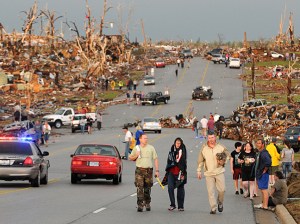
“The largest earthquake ever reported in the state of Oklahoma struck Saturday night, officials said.
The temblor had a magnitude of 5.6 and its epicenter was four miles east of Sparks in Lincoln County, according to the Oklahoma Geological Survey. The quake hit at 10:53 p.m.
The quake was reportedly felt as far away as Illinois, Kansas, Arkansas and Texas.
‘There’s a crack going from the closet to the ceiling. I’ve never seen that before. I was in my bedroom grabbing my phone and I happened to notice it,’ Moore resident Todd McKinsey said.
McKinsey said he lives near NW 12 and Santa Fe Avenue.
‘That’s drywall. It’s totally separated,’ he said.
‘Earthquake damage in Oklahoma, that’s an anomaly right there,’ McKinsey said.
‘The picture by the TV fell off the wall and we jumped up because we thought somebody had hit the house,’ Noeh Morales said.
‘It was like a roaring noise. I’ve never one that bad over here,’ he said.
Morales said he was asleep at his home near SW 69 and Pennsylvania Avenue.
‘It woke me out of a dead sleep. I felt the whole house shaking. I jumped and ran outside to see what was going on,’ he said.
The strongest earthquake previously reported was April 9, 1952 in El Reno, according to the geological survey. Its magnitude was 5.50.
The Lincoln County sheriff’s office said late Saturday that damage has been reported across the county, but were still responding to calls and was not sure of the extent of damage. The Oklahoma City fire department reported no injuries or serious damage as of 11:15 p.m.” Source – NewsOK.
Multiple Earthquakes Shake Central Oklahoma Saturday, Felt as Far Away as Missouri and Arkansas

Update: An even stronger 5.6 earthquake struck Oklahoma Saturday evening. Read more.
“OKLAHOMA CITY – Authorities say three earthquakes that have shaken much of central Oklahoma could be felt as far away as Kansas, Missouri and Arkansas.
The U.S. Geological Survey says on its website early Saturday morning that a 4.7 magnitude earthquake struck at 2:12 a.m., with an epicenter about six miles north of Prague in southern Lincoln County. That’s about 50 miles east of Oklahoma City.
A 3.4 magnitude aftershock was reported at 2:27 a.m. from the same location.
The survey says a 2.7 magnitude quake also was recorded at 2:44 a.m.
Lincoln County sheriff officials say there have been no reports of injuries but several people have reported items falling off walls.” Source – Associated Press.
3.6 Magnitude Earthquake Hit Near Kendrick Saturday – “A 3.6 magnitude earthquake was reported in Lincoln County Saturday night. According to the U.S. Geological Survey, the quake hit about 11:05 p.m. four miles northwest of Kendrick and about five miles southeast of Agra. The earthquake was about 47 miles northeast of Oklahoma City.” Read more.
Study: Earthquakes Have Claimed More Than 780,000 Over Past Ten Years — 60% of All Disaster-Related Deaths
 “EARTHQUAKES claimed more than 780,000 lives in the past decade, accounting for nearly 60 per cent of all disaster-related deaths, according to a study published in The Lancet today.
‘In addition to these deaths, earthquakes have directly affected another two billion people in this period,’ it added.
The deadliest quake was the January 12 2010 7.0-magnitude event in Haiti which killed 316,000 people.
This was followed by the December 26 2004 Indian Ocean tsunami, generated by a 9.1-magnitude tremor, in which 227,000 people died.
Third-ranked was the May 12 2008 7.9-magnitude quake in south-western China’s Sichuan province, which inflicted a death toll of 87,500.
The review study seeks to give emergency responders and policymakers a snapshot of the scale of earthquakes as a health priority, and to warn doctors about the kind of injuries they are likely to confront.
‘Massive earthquakes can result in casualty rates ranging from one to eight per cent of the at-risk population,’ it said.
‘The reported ratios of death-to-injury vary, but across many studies seems to be about 1-to-3.’
The death toll unfurls in waves, starting with immediate fatalities from falling buildings, which is followed several hours later as people die from catastrophic injuries to internal organs, says the investigation.
A third wave occurs in the days to weeks afterwards among people with sepsis and multiple organ failure.
Among survivors, the main injuries are crush-related damage to the kidneys, liver and spleen, followed by spinal damage, bone fractures and lacerations.” Read more.
Geologists Closely Monitoring Surge in Central Arkansas Earthquakes, Layout of Tremors Could Suggest Larger Quake Coming
 By Gavin Lesnick – “LITTLE ROCK — The Arkansas Geological Survey says it is stepping up its monitoring of seismic activity in central Arkansas after dozens of small earthquakes in the region.
Six minor quakes were recorded Friday near Quitman, the latest of more than 50 temblors in October. The Friday tremors began with a 2.0-magnitude quake around 7:45 a.m. and peaked with a 2.5 quake later in the morning.
The shaking follows more than 1,000 earthquakes centered between Guy and Greenbrier from September 2010 to July of this year, when the Arkansas Oil and Gas Commission ordered four gas disposal wells shut down and voted to create a large moratorium area in which no future disposal wells could be drilled.
Geologists said the activity – which involves injecting pressurized liquid into the ground – was likely contributing to the shaking.
The quakes between Guy and Greenbrier tailed off significantly in August, but more quakes began occurring in October closer to Quitman. It sits about 10 miles northeast of Guy.
That distance is potentially concerning, warned Scott Ausbrooks, geohazards supervisor for the Arkansas Geological Survey. The Quitman quakes are occurring along the same line as the Guy-Greenbrier ones, but there’s a miles-long gap between Guy and Quitman in which no quakes have been recorded.
That might suggest that the tension is building, possibly leading up to a larger quake centered on that gap along the fault. A similar-sized gap occurred on the southern end of the Guy-Greenbrier fault and it in February unleashed a 4.7-magnitude quake, the largest of any of the recent tremors.
Anytime there is a gap in seismicity along an active fault, it ‘bears watching,’ Ausbrooks said.” Read more.
Strong 6.9 Magnitude Earthquake Rattles Peru, Knocks Out Power
 Richter Magnitude 6.9 – NEAR THE COAST OF CENTRAL PERU
Friday, October 28, 2011 at 01:54:33 PM at epicenter
14.515°S, 76.009°W
Depth: 23.9 km (14.9 miles)
“A magnitude 6.9 earthquake struck off the west coast of Peru, rattling residents in cities still recovering from a temblor that killed more than 500 people in 2007. No fatalities were immediately reported.
The temblor knocked out power and sent people running from their homes near its center 178 miles (286 kilometers) south- southeast of Lima. In Ica, which was devastated by the magnitude-8 quake in 2007, a cathedral wall and church tower collapsed, along with several mud brick buildings, said Juan Carlos Romani, a spokesman for the city council.
‘It was very strong but quick,’ said Romani in a telephone interview from Ica, adding that there were no reports of injuries, though power and phone service hadn’t fully returned. ‘It lasted ten seconds at most but was very violent.’
In Lima, buildings shook for about a minute, and had to be evacuated amid aftershocks, though no damage was immediately reported in the capital.” Read more.
Obama Has Declared Record-Breaking 89 Disasters So Far in 2011
 By Amy Bingham – “From Hurricane Irene, which soaked the entire East Coast in August, to the Midwest tornadoes, which wrought havoc from Wisconsin to Texas, 2011 has seen more billion-dollar natural disasters than any year on record, according to the National Climatic Data Center.
And as America’s hurricanes, floods, tornadoes and wildfires set records this year, so too has President Obama in his response to them.
During the first 10 months of this year President Obama declared 89 major disasters, more than the record 81 declarations that he made in all of 2010.
And Obama has declared more disasters — 229 — in the first three years of his presidency than almost any other president signed in their full four-year terms. Only President George W. Bush declared more, having signed 238 disaster declarations in his second term, from 2005 to 2009.
But while the sheer number of bad weather events played a big role in the uptick in presidential disaster declarations, Obama’s record-setting year may have something to do with politics as well.
‘There’s no question about it that the increase in the number of disaster declarations is outstripping what we would expect to see, given what we observe in terms of weather,’ said Robert Hartwig, the president and economist at the Insurance Information Institute. ‘There’s a lot of political pressure on the president and Congress to show they are responsive to these sorts of disasters that occur.’
While the president aimed to authorize swift and sweeping aid to disaster victims, Congress was entrenched in partisan battles over how to foot the bill.” Read more.
Flashback: Nature is pummeling the US this year with extremes – “Nature is pummeling the United States this year with extremes. Unprecedented triple-digit heat and devastating drought. Deadly tornadoes leveling towns. Massive rivers overflowing. A billion-dollar blizzard. And now, unusual hurricane-caused flooding in Vermont. If what’s falling from the sky isn’t enough, the ground shook in places that normally seem stable: Colorado and the entire East Coast. On Friday, a strong quake triggered brief tsunami warnings in Alaska. Arizona and New Mexico have broken records for wildfires.” Read more.
Turkey: Seismologists Fear Eruption of Nemrut Volcano After Massive 7.2 Earthquake
 “TURKISH seismologists fear that the earthquakes that hit the province of Van on Sunday can cause eruption of Nemrut volcano located northwards of Lake Van, PanArmenian reported.
Mt Nemrut is near Tatvan, a small town in the eastern Anatolian province of Bitlis. The mountain rises from the southwestern shore of Lake Van, and enters the district of Ahlat to the north.
At least 217 were killed and more than 1,000 people injured when a powerful earthquake struck Turkey, collapsing dozens of buildings and pulling down phone and power lines in the southeast of the country, officials and witnesses said. More than 1,000 people are feared killed in the earthquake.
Another magnitude 6.1 earthquake, which was the second to rock the country in the past 24 hours, was registered about 20 km from the city of Van at the depth of some 10 km.” Source.
Deadly 7.2 Magnitude Earthquake Rocks Eastern Turkey, Dozens of Buildings Collapse, Significant Casualties Reported

Richter Magnitude 7.2 – EASTERN TURKEY
Sunday, October 23, 2011 at 01:41:21 PM
38.628°N, 43.486°E
Depth: 20 km (12.4 miles)
“A powerful earthquake with a magnitude of 7.2 shook southeastern Turkey on Sunday, Turkey’s Kandilli Observatory said, triggering the collapse of buildings and killing scores of people.
Turkey’s main seismography center says the quake could have killed up to 1,000 people.
The Kandilli observatory’s estimate is based on the strength of the quake and the structure of the housing in the area.
‘We are estimating a death toll between 500 and 1,000,’ Mustafa Erdik, head of the Kandilli observatory, told a televised news conference Sunday.
 Turkey’s deputy prime minister said around 45 buildings have collapsed in the town of Ercis and the city of Van. Ercis sits on a geological fault line.
‘A lot of buildings collapsed, many people killed, but we don’t know the number. We are waiting for emergency help, its very urgent,’ Zulfukar Arapoglu, the mayor of Ercis district, which was hit badly, told the news broadcaster NTV.” Read more.
Japan: 3/11 Earthquake Caused Archipelago to Move Eight Feet East and Sunk The Nation Nearly One Inch
 By Julian Ryall – “The massive earthquake that struck Japan in March shifted the entire archipelago nearly 8 feet closer to the United States and caused the nation to sink close to 1 inch.
The magnitude-9 quake – the largest in recorded history in Japan – also jolted the planet on its axis by nearly 4 inches.
Experts at the Geospatial Information Authority of Japan have confirmed that the standard datum of levelling – the benchmark for measuring heights above sea level throughout Japan – sank 2.4cm (0.9 inch) as a result of the earthquake.
The change in the figure was the first since the Great Kanto Earthquake killed an estimated 105,000 people in Tokyo in 1932.
That quake had a magnitude of 8.2 and caused the ground level to sink 3.4 inches into the Pacific.
The movements were even more pronounced in parts of north-east Japan that were closest to the epicentre of the earthquake.
Experts and the GIA have calculated that the Oshika Peninsula, just to the north of the devastated town of Ishinomaki, shifted more than 17 feet to the east and sank nearly 4 feet into the Pacific Ocean. Both figures are records for land mass movements caused by a tremor in Japan, and the impact is clearly visible in the villages that dot the inlets of the peninsula.
Concrete jetties for local fishing boats are now beneath the surface of the water and the pine forests that grew above the former high tide mark have turned brown and died as their roots come into contact with salt water.” Source.
 Israel National News
- Netanyahu: Guy Ludar fought with courage and bravery to protect our communities and citizens
- IDF: Disarming Hezbollah is not a military objective
- IDF strikes Iranian petrochemical complex
- Over 200 targets struck in Iran and Lebanon
- Report: Iranian missile launched missile parallel to Houthi launch landed in Jordan
- Missile launched from Yemen fell in open area, none injured
- IAF pounds Tehran: Air defenses, missile hubs and R&D sites hit
- Sirens sounding in central Israel
- Launches from Yemen detected towards central Israel, Judea, and Samaria
- Trump threatens: Iran has 48 hours before the gates of hell open
FrontPage Magazine
- Victory Over Death
- “Anti-Zionism” vs. the Resurrection
- What is ‘Good’ About Good Friday
- Hope For the Dead
- The Truth About Israel’s ‘Death Penalty for Terrorists Bill’
- Absurdly Evil: Georgetown Prof Jonathan A. C. Brown
- Anti-Israel Art In – A Holocaust Survivor Nearly Shut Out
- Spencer Video: Anni Cyrus is an Indispensable Voice at a Critical Time
- One Month On, How the War Against Iran is Going
- The Islamic Republic of Iran: A Rogue State
Gatestone Institute
- With Friends Like These: America and Its Fake Allies
- Islamic State Weaponising Social Media for Radicalisation: Exploding Threat in the Indo-Pacific
- Egypt's Dangerous Muslim Brotherhood Organization
- A Free World Opportunity
- Syria: Christians, Other Minorities Under Genocidal Attack During Leadership of Ahmed Al-Sharaa
- The Sham of 'Disarming' Hamas
- US Congress Confronts Bangladesh Genocide—But Ignores the Islamist Infrastructure Behind It
- The War on Civilization: 'Israel Cannot Outsource Its Survival'
- Iran: The Danger of the Venezuelan Model
- Finish the Job: Leaving Iran's Regime in Place Guarantees Endless Regional Instability
Middle East – The Jerusalem Post
- Trump gives Iran 48 hours to make a deal before 'all hell reigns', hunt goes on for US pilot
- Former IRGC child executioner tells ‘Post’ how he became devout Christian dissident
- Hezbollah sees potential win as Israel backs down from disarmament goal - analysis
- Iranian drone attack on US embassy in Riyadh more destructive than initially revealed - report
- Debris fall in Dubai marina after aerial interception, one killed by shrapnel in Abu Dhabi
- Second US fighter jet downed in Persian Gulf, pilot rescued after ejection
- US intelligence warns Iran unlikely to ease Hormuz Strait chokehold soon, sources say
- US-Iran ceasefire talks reach standstill, say mediators - report
- IDF strikes Hamas terror cell operating near Israeli troops in northern Gaza
- Iraqi PMF presence in Iran raises alarm over crackdown, potential US ground war
Earthquakes & Volcanic Activity
- World Earthquake Report for Saturday, 4 April 2026
- Mayon Volcano Volcanic Ash Advisory: ERUPTION AT 20260404/1837Z VA CLD UNKNOWN REPORTED OBS VA DTG: 04/1830Z
- Semeru Volcano Volcanic Ash Advisory: VA TO FL150 OBS ON SAT MOV SW 04/1820Z EST VA DTG: 04/1820Z to 15000 ft (4600 m)
- World Earthquake Report for April 2026
- Volcanoes Today, 4 Apr 2026: Fuego volcano, Shiveluch, Dukono, Marapi, Reventador, Mayon, Sangay, Sabancaya
- Dukono Volcano Volcanic Ash Advisory: VA TO FL100 OBSERVED ON SAT IMAGERY EXT SW OBS VA DTG: 04/1520Z to 10000 ft (3000 m)
- Sabancaya Volcano Volcanic Ash Advisory: NO VA EMS
- Sangay Volcano Volcanic Ash Advisory: OCNL VA EMS to 22000 ft (6700 m)
- Reventador Volcano Volcanic Ash Advisory: PSBL VA EMS to 16000 ft (4900 m)
- Fuego Volcano Volcanic Ash Advisory: VA OBS IN WEBCAM
Islamic Terrorist Network In America

Click For Larger Version


Click To Learn What Makes This An Idol


Recent Comments