Archive
New York: Tornado Reported Near Amsterdam, ‘There Are Reports of Damage to Numerous Structures’
 “Syracuse, N.Y. — Numerous buildings in the Amsterdam area have reportedly been damaged this evening by what appeared to be a tornado, Gov. Andrew Cuomo announced at about 9 p.m.
‘At this time, there have been no reports of any serious injuries, but there are reports of damage to numerous structures,’ Cuomo said. ‘I have dispatched the state police as well as state urban search and rescue personnel, who were in the area for Hurricane Irene assignments, to lead the state’s response and to assess the damage. Power crews are also on the scene to restore electricity to any customers who may have been affected.’
The National Weather Service issued a flash flood warning at 5:30 p.m. today for Montgomery County, southern Fulton and southern Herkimer counties. Severe thunderstorms dumped one to two inches of rain in the region, it said.” Source.
Nearly 6,000 Evacuated in New Orleans Ahead of Lee’s Heavy Rain
 “NEW ORLEANS – Around 6,000 people from Jefferson Parish in New Orleans were evacuated Saturday as Tropical Storm Lee began to pelt the Gulf Coast.
Bands of heavy rain and strong wind gusts knocked out power to thousands in south Louisiana and Mississippi and prompted evacuations in bayou towns like Jean Lafitte, where water lapped at several front doors along the main highway.
The sluggish storm stalled just before making landfall, and threatened to dump more than a foot of rain across the northern Gulf Coast and into the Southeast in coming days. No injuries were reported and there were only scattered reports of water entering low-lying homes and businesses.
The center of the slow-moving storm was about 45 southwest of Morgan City, La., Saturday afternoon, spinning intermittent bands of stormy weather, alternating with light rain and occasional sunshine. Its maximum sustained winds were 60 mph.
The National Weather Service in Slidell reported two-day rain totals approaching 9 inches in parts of south Louisiana and more than 5 inches near the Mississippi coast.
It was expected to cross the Louisiana coast Saturday and meander through the state’s southern parishes through Sunday.
Tropical storm warning flags were flying from Alabama to Texas and flash flood warnings extended along the Alabama coast into the Florida Panhandle.” Read more.
Indonesia: Officials Raise Alert Level After Increased Activity at 22 Volcanoes
 By Adianto P. Simamora – “The government has requested that local administrations remain on the alert for severe risks of volcanic eruptions, as the number of volcanoes showing abnormal activity continued to raise.
As of Friday, activity in 22 volcanoes was categorized as above normal, with six at alert level three and 16 at level two. Volcano status ranges from level one, which is normal, to four, which is the highest alert.
The Volcanology and Geophysical Disaster Mitigation Center (PVMBG) raised the status of Papandayan, one of the major tourist destinations in Garut, West Java, to alert level three on Friday.
‘There were 48 shallow volcanic earthquakes detected, with one deep volcanic earthquake and a white cloud emitted as high as 20 meters on Thursday,’ National Disaster Management Agency (BNPB) spokesman Sutopo Purwo Nugroho said.
Sutopo added that his office had prepared contingency plans to anticipate worst-case scenarios if
Papandayan erupts.
‘If Papandayan erupts, it would impact 171,744 people living in the five subdistricts and 20 villages,’ he said.” Read more.
Major Typhoon Headed to Japan, Worries Grow About Heavy Rainfalls in Disaster Zone
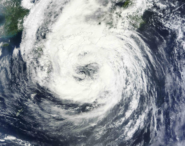 “TOKYO — A major typhoon is headed toward Japan and is expected to cross over the western and central areas of the archipelago Friday and Saturday.
The Japan Meteorological Agency said Typhoon Talas was traveling slowly at 6 miles per hour (10 kilometers per hour) on Friday. It packed winds of up to 110 mph (180 kph) and setting off downpours and strong winds.
The typhoon was expected to cause rainfalls for long periods, because of its relative slow speed. Among the rain-affected will be the northeastern part of Japan devastated by the March 11 earthquake and tsunami, and still covered in mud and rubble.” Read more.
2200 evacuated as typhoon ‘Talas’ lashes Japan – “OSAKA – Powerful typhoon made a landfall in Shikoku Island in western Japan on Saturday, forcing more than 2, 200 people to evacuate in 12 prefectures in western to central Japan, the Japan Meteorological Agency said. As of 10 amlocal time, Talas, the season’s 12th typhoon, landed in Kochi Prefecture in Shikokku Island, packing winds of up to 144 kms/h near its center, the weather agency said. The typhoon has left one dead, three missing and at least 27 people injuried across Japan, according to a NHK report. Because of the slow-moving nature of the typhoon, heavy rain and storms persist across a wide area of the Japanese archipelago, the weather agency said, warning of mudslides and floods.” Read more.
Disasters in US: An Extreme and Exhausting Year
 By SETH BORENSTEIN – “WASHINGTON (AP) — Nature is pummeling the United States this year with extremes.
Unprecedented triple-digit heat and devastating drought. Deadly tornadoes leveling towns. Massive rivers overflowing. A billion-dollar blizzard. And now, unusual hurricane-caused flooding in Vermont.
If what’s falling from the sky isn’t enough, the ground shook in places that normally seem stable: Colorado and the entire East Coast. On Friday, a strong quake triggered brief tsunami warnings in Alaska. Arizona and New Mexico have broken records for wildfires.
Total weather losses top $35 billion, and that’s not counting Hurricane Irene, according to the National Oceanic Atmospheric Administration. There have been more than 700 U.S. disaster and weather deaths, most from the tornado outbreaks this spring.
Last year, the world seemed to go wild with natural disasters in the deadliest year in a generation. But 2010 was bad globally, and the United States mostly was spared.
This year, while there have been devastating events elsewhere, such as the earthquake and tsunami in Japan, Australia’s flooding and a drought in Africa, it’s our turn to get smacked. Repeatedly.” Read more.
Despite Weaker Than Expected Winds, Irene Leaves Path of Devastation: 44+ Dead, Millions Without Power, Widespread Flooding
 “The full measure of Hurricane Irene’s fury came into focus Monday as the death toll passed 44, while towns in the northern U.S. region of New England battled epic floods and millions were still without electricity.
From North Carolina to Maine, communities cleaned up and took stock of the uneven and hard-to-predict costs of a storm that spared the nation’s biggest city a nightmare scenario, only to deliver a historic wallop to towns well inland.
In New York City, where people had braced for a disaster-movie scene of water swirling around skyscrapers, the subways and buses were up and running again in time for the Monday morning commute. And to the surprise of many New Yorkers, things went pretty smoothly.
But to the north, landlocked Vermont contended with what its governor called the worst flooding in a century. Streams also raged out of control in rural, upstate New York.
In many cases, the moment of maximum danger arrived well after the storm had passed, as rainwater made its way into rivers and streams and turned them into torrents. Irene dumped up to 11 inches of rain on Vermont and more than 13 inches in parts of New York.
‘We were expecting heavy rains,’ said Bobbi-Jean Jeun of Clarksville, a hamlet near Albany, New York. ‘We were expecting flooding. We weren’t expecting devastation. It looks like somebody set a bomb off.’
Irene killed at least five people in the Dominican Republic and Haiti. The first known casualty was a woman who died trying to cross a swollen river in the U.S. territory of Puerto Rico.
The death toll for 11 eastern U.S. states had stood at 21 as of Sunday night, then rose sharply to at least 38 as bodies were pulled from floodwaters and people were struck by falling trees or electrocuted by downed power lines.
A driver was missing after a road collapsed and swallowed two cars about 62 miles northeast of Montreal.” Read more.
Irene forecasts on track; not up to speed on wind – “Hurricane Irene was no mystery to forecasters. They knew where it was going. But what it would do when it got there was another matter. Predicting a storm’s strength still baffles meteorologists. Every giant step in figuring out the path highlights how little progress they’ve made on another crucial question: How strong? Irene made landfall Saturday morning at Cape Lookout, N.C. – a bull’s-eye in the field of weather forecasts. It hit where forecasters said it would and followed the track they had been warning about for days. ‘People see that and assume we can predict everything,’ National Hurricane Center senior forecaster Richard Pasch said. But when Irene struck, the storm did not stick with the forecast’s predicted major hurricane strength winds.” Read more.
Hurricane Irene Leaves Trail of Damage Far Inland – “Residents along the Eastern seaboard faced a massive cleanup effort Monday after Hurricane Irene pounded tens of millions of Americans with wind, rain and floods. The huge size and slow journey of the storm along 1,100 miles of U.S. coastline left an extraordinarily broad impact. At least 24 deaths were attributed to Irene as devastation ranged from North Carolina to Vermont. Toppled trees, fallen debris and flooding caused hundreds of roads to be closed over the weekend. Up and down the coast, some 2.4 million people evacuated. In New Jersey, the ocean surge and rainfall caused severe inland flooding. Gov. Chris Christie said damages there would total at least $1 billion and could reach ‘tens of billions of dollars.’ Virginia’s governor called the blackout in his state its second-largest ever and warned that electricity might not be restored for a week.” Read more.
Oklahoma: Nearly 1000 Fish Go Belly-Up in Enid Lake at Meadowlake Park
 By Ed Doney – “ENID, Okla. — A dead fish floating in a lake is not uncommon, but Enid officials were notified Tuesday of a sight rarely seen. Nearly 1,000 dead crappie were floating at Meadowlake Park.
‘Some had been decaying for three or four days,’ Rob Camp said, Deputy Director of Enid Public Works. ‘We found some, just regular skeletons.’
Camp said they found no evidence of contamination and other lake wildlife seem to be fine.
But their pH tests revealed the lake water’s acid level was too low.
Why? This summer’s record heat.
Water this hot throws off a balanced ecosystem and affects more sensitive fish, like crappie.
‘They’re not as strong or as versatile a fish that can survive in those types of environments,’ Camp said. ‘So they’re usually the first ones to die off.’
Micah Holmes, with the Oklahoma Department of Wildlife Conservation, said their biologists tested the lake water Tuesday and blame low oxygen levels.” Read more.
Hurricane Irene Looks ‘Terrifying’ From Space, Astronaut Says
 “Hurricane Irene is bearing down on the U.S. East Coast and has turned into a frightening storm, according to an astronaut on the International Space Station.
NASA astronaut Mike Fossum said that Hurricane Irene, like all hurricanes, looks ‘terrifying from above,’ and its evolution into a major storm this week has been unmistakable from orbit.
‘We saw a big change in the structure of the storm over the several days that we’ve watched her, especially yesterday,’ Fossum told SPACE.com today (Aug. 25) during a video interview from space.
Hurricane Irene is currently a Category 3 storm with winds of 115 mph (185 kph) that is battering the Bahamas. Space station astronauts and satellites have kept a constant watch on the growing storm.
The storm is expected to hit the North Carolina coast on Saturday (Aug. 27) and follow the coastline north, where it may make landfall on Long Island, posing a threat to New York City, according to OurAmazingPlanet, a sister site of SPACE.com.” Read more.
NYC mayor orders Zone A nursing homes to evacuate – “Mayor Michael Bloomberg has ordered nursing, senior homes and hospitals in Zone A low-lying areas to evacuate beginning Friday. He asked these facilities and hospitals to coordinate evacuation efforts with health officials. The mayor at a press conference Thursday said Hurricane Irene appears to be heading toward eastern Queens, New York. Bloomberg says shelters will open for residents at 4 p.m. Friday. He also announced that the emergency command center had been activated.” Read more.
Hurricane Irene: As many as 200,000 evacuate in North Carolina – “For thousands of tourists in the barrier islands off North Carolina, the threat of Hurricane Irene has just cut their vacations short. On Thursday, state officials ordered tourists to pack up the sand toys and abandon the beach rentals. Residents have been asked to find a safe spot farther inland as well. Local news reports pegged the number of evacuees — tourists as well as residents — at 200,000, although Ernie Seneca, a spokesman for North Carolina Division of Emergency Management, said he was unable to confirm it. It did not surprise him, however.” Read more.
Major Threat: Millions Will Be Affected As Irene Is Poised To Become The Strongest Hurricane To Hit The Northeast In Decades

“Our projected path map below continues to paint an ominous picture by pointing Hurricane Irene right in the direction of the East Coast this weekend. The latest computer model guidance confirms this threat and the first hurricane watches have been issued for the United States.
The potential is real for the strongest hurricane hit on the Northeast in at least a couple decades this weekend!
Let’s lay out all the potential threats and timing involved with Hurricane Irene.
High winds
The 5 a.m. EDT forecast discussion Tuesday from Stacy Stewart, Sr. Hurricane Specialist at the National Hurricane Center mentioned Hurricane Irene is “forecast to become a larger than average hurricane.”
This means its wind field, both of tropical storm-force and hurricane-force winds, will cover a large swath of real estate. Reason again not to focus solely on the path of the center of circulation, although it is around and especially east of the eye where the strongest winds will be.
Our graphic below highlights the general area of wind threat from Hurricane Irene. As you can see, a large swath of the Northeast may see power outages and downed trees. The severity will be dictated by Irene’s exact path and intensity, which remain uncertain at this time.
-
Timing: Conditions deteriorate Saturday night. Strongest winds Sunday. Lingering strong winds possible Sunday night into early Monday in New England.
-
Possible impacts: Widespread trees downed, power outages, particularly near the coast. Potential for some structural damage in strongest gusts near center of Irene.” Read more.
Indonesia: Volcano Agency Warns of Likely Mount Papandayan Eruption
 “Indonesia’s highly active Mount Papandayan volcano is in imminent danger of erupting, the Volcanology and Geological Disaster Mitigation Agency warned on Wednesday.
The agency, known as the PVMGB, said it was likely the volcano in Garut, West Java, would erupt either before or just after Idul Fitri, which marks the end of Ramadan.
The prediction was based on the increasing activity of the volcano, the agency said on its Web site.
‘The volcano has more energy compared to its last eruption in 2002,’ agency head Surono said in Bandung, the provincial capital, on Tuesday.
Papandayan has shown an alarming increase in activities since the volcano’s status was raised to standby. Between Aug. 19 and 20, there were 45 earthquakes.
‘If the quakes increase to 60, an eruption will happen,’ he said. ‘If Papandayan erupts, the annual exodus [mudik] routes will be blocked and 16 subdistricts in Garut will be isolated.'” Read more.
Hurricane Irene: Prepare for a Category 4 ‘Major Hurricane’
“Hurricane Irene continues to grow in strength and ferocity and is now on track to become a Category 4 hurricane, authorities said. Fueled by warm waters and nothing to slow it down, the hurricane is taking a path that will likely skirt Florida and head straight for the Carolinas, with landfall this weekend.
The National Hurricane Center warns that the storm remains unpredictable and is urging East Coast residents to closely track the first major hurricane of the 2011 season as it heads toward the United States so that they can be prepared for impact.
The storm, which is now a Category 2 hurricane, is moving at about 12 mph and is currently north of the Dominican Republic, said National Hurricane Center spokesman Dennis Feltgen in an interview with The Times. Unfortunately, that means “it’s moving into an environment which is very ideal for strengthening. … We expect it to become a Category 4 hurricane as it passes east of central Florida.’
The warm ocean waters and very low wind shear are the two key factors driving the hurricane, he said. High wind shear could help disrupt the storm, scattering it.
‘We expect the storm to stay off the coast of Florida, which is good news for Florida. But it’s still looking like it’s going to impact the Carolinas and could make landfall there as a major hurricane.'” Source.
Looks Like Irene May Become Major Category 3 Hurricane, Carolinas Targeted
Update: Make that a Category 4. Read here.
 By Kristina Pydynowski – “Irene is destined to strike the southeastern United States later this week as a major hurricane. Residents in the Carolinas are urged to begin preparations.
The AccuWeather.com Hurricane Center is expecting Irene to target the Carolinas after emerging from the Bahamas later this week.
AccuWeather.com Expert Senior Meteorologist Alex Sosnowski has the latest details on how bad it will be for the Carolinas.
Irene strengthened into the season’s first hurricane as it pounded Puerto Rico early Monday morning.
The hurricane will continue its assault on the Greater Antilles in the Caribbean prior to reaching the Bahamas.
As Irene plows through the Bahamas, the storm is forecast to become a major Category 3 hurricane this week.
Exactly when and where Irene moves onshore with its torrential rain, destructive winds and flooding storm surge depends on how soon the storm tracks in a more northward fashion instead of its current northwestward heading.
The AccuWeather.com Hurricane Center currently expects landfall to be somewhere between the North Carolina-South Carolina and Wilmington, N.C., the first part of this weekend. Since the track has had a tendency to shift east, residents farther northeast along the North Carolina coast need to pay close attention to this storm as well.
According to Sosnowski, ‘Often, the worst effects of a hurricane moving in this manner are on the northeastern quadrant of the storm, which would involve at least part of eastern North Carolina.'” Read more.
 Israel National News
- Unconditional surrender and reform
- Report: Russia giving satellite images of US forces to Iran
- Over 100 UNRWA employees under investigation for Hamas links
- Iran launches missile attack on Israel
- UNICEF banned from Egypt crossing for smuggling attempt
- Why the global conflict of 2026 is written in your Haggadah
- Hezbollah fires dozens of rockets at northern Israel
- Weekly Tanya video/lecture: Igeres Hakodesh
- Hezbollah launches rocket attack on multiple areas in Israel
- IDF Spokesman: 'We'll reach all Iranian leaders, anywhere, anytime'
FrontPage Magazine
- Counterterrorism Boss Joe Kent Resigns
- Canada: School Bans Kids From Eating To Not Offend Muslims During Ramadan
- Obama Presidential Center Shows Us Once Again How Socialism Really Works
- Paul Ehrlich is Dead and Nobody is Eating Him
- Michael Finch Video: The Left’s Drive to Make a Cesspool out of America
- Mojtaba’s Empire
- In London, A Sikh Restaurant Owner Posts ‘No Halal Meat Sold Here’ Sign
- A False Prophet in Texas
- Iranian Leader Who Threatened Trump Would Disappear Taken Out
- California May Add 2 Muslim State Holidays While Christians Have Only One
Gatestone Institute
- Why Applying the 'Venezuela Method' to Iran Would Be a Terrible Mistake
- Hamas Crimes No One Talks About
- Trump's Iran War Ending Xi Jinping's 'China Dream'
- Iran Gets a New Supreme Guide
- 'Trump Derangement Syndrome': The Danger of Hatred Clouding Perception
- Spain's Pedro Sánchez and His Extremist Problem
- Before Pouring Billions into Gaza, Trump's 'Board of Peace' Needs To Ask A Few Hard Questions
- If Saudi Arabia Wants U.S. Alliance, It Must End Support for Sudanese Armed Forces — Aligned with Muslim Brotherhood and Iran — Not Fund It
- UN and EU Condemn the Strike, Not the Regime: Double Standards, Selective Outrage
- Why Fusion Energy Needs to Be American Born – Now More Than Ever
Middle East – The Jerusalem Post
- Reports of large US invasion to get Iran 60% nuke uranium likely overblown - exclusive
- Trump's operation in Strait of Hormuz could extend war with Iran by months, sources tell Post
- US encourages Syrian action against Hezbollah, Damascus is hesitant, sources say
- US intelligence says Iranian regime change unlikely, IRGC maintains power - report
- Despite pushing uprising, Israeli officials believe Iranian protesters will be slaughtered - report
- Turkey's Ambassador to Syria, Nuh Yilmaz, presents credentials to President Sharaa in Damascus
- Trump says US will leave Iran operation in 'very near future'
- Pressure building on Houthis to act as group stays on sidelines amid Iran war, expert tells 'Post'
- What is Basij? The Islamic Republic's 'iron fist' to suppress protesters - explainer
- Kuwait arrests 16-member Hezbollah terror cell, seizes weapons, drones, Morse code transmitters
Earthquakes & Volcanic Activity
- World Earthquake Report for Tuesday, 17 March 2026
- Mayon Volcano Volcanic Ash Advisory: ERUPTION AT 20260317/2059Z VA CLD UNKNOWN REPORTED OBS VA DTG: 17/2050Z
- Volcanic activity worldwide 17 Mar 2026: Fuego volcano, Shiveluch, Ibu, Reventador, Mayon, Piton de ...
- Fuego Volcano Volcanic Ash Advisory: OCNL VA EMS
- World Earthquake Report for March 2026
- Volcanoes Today, 17 Mar 2026: Fuego volcano, Shiveluch, Ibu, Reventador, Mayon, Piton de la Fournaise, Sangay, Lewotolo
- Shiveluch Volcano Volcanic Ash Advisory: RESIDUAL VA to 32000 ft (9800 m)
- Reventador Volcano Volcanic Ash Advisory: PSBL VA EMS
- Sangay Volcano Volcanic Ash Advisory: NEW RPRT OF VA AT FL220 to 22000 ft (6700 m)
- Ibu Volcano Volcanic Ash Advisory: VA TO FL070 LAST REP AT 17/1104Z EST VA DTG: 17/1130Z to 7000 ft (2100 m)
Islamic Terrorist Network In America

Click For Larger Version


Click To Learn What Makes This An Idol


Recent Comments