Archive
Levee Blast Means Lost Year for Missouri Farmers
 By JIM SALTER, MICHAEL J. CRUMB – “WYATT, Mo. — Blasting open a levee and submerging more than 200 square miles of Missouri farmland has likely gouged away fertile topsoil, deposited mountains of debris to clear and may even hamper farming in some places for years, experts say.
The planned explosions this week to ease the Mississippi River flooding threatening the town of Cairo, Ill., appear to have succeeded — but their effects on the farmland, where wheat, corn and soybeans are grown — could take months or even years to become clear. The Missouri Farm Bureau said the damage will likely exceed $100 million for this year alone.
‘Where the breach is, water just roars through and scours the ground. It’s like pouring water in a sand pile. There is that deep crevice that’s created,’ said John Hawkins, a spokesman for the Illinois Farm Bureau. ‘For some farmers, it could take a generation to recoup that area.'” Read more.
Record Wildlife Die-Offs Reported in Northern Rockies
 By Laura Zuckerman -“SALMON, Idaho (Reuters) – A record number of big-game animals perished this winter in parts of Montana, Idaho and Wyoming from a harsh season of unusually heavy snows and sustained cold in the Northern Rockies, state wildlife managers say.
‘Elk, deer and moose — those animals are having a pretty tough time,’ said Wyoming Game and Fish biologist Doug Brimeyer.
Snow and frigid temperatures in pockets of Idaho, Montana and Wyoming arrived earlier and lingered longer than usual, extending the time that wildlife were forced to forage on low reserves for scarce food, leading more of them to starve.
Based on aerial surveys of big-game herds and signals from radio-collared animals, experts are documenting high mortality among offspring of mule deer, white-tailed deer and pronghorn antelope.
This comes as big-game animals enter the last stretch of a period from mid-March through early May that is considered critical for survival.” Read more.
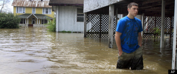
Flowing Backwards: Mississippi Flood More Than Historic, It’s a 500 Year ‘Epic’ Flood
 By Lauren Lee – “MEMPHIS, Tenn. – The Mississippi River continues to rise, so much so that its tributaries are starting to flow backwards. At Tom Lee Park, preps for Memphis in May continue knowing that the worst is still yet to come.
It’s a site not often seen; the Wolf River and Nonconnah Creek are flowing backwards. The swelling river cannot take on much more water.
Gene Rench with the National Weather Service said all eyes are on the Mississippi. The tributaries flowing backwards are a big problem for the adjacent communities.
‘Right now the Mississippi river is in the process of going through what we call an epic flood, meaning it’s more than historic, it’s more than a 100 year flood, it’s more like a 500 year flood,’ he said. ‘We could flood many homes, businesses, close down factories, people could drown.’
The river is more than two feet past flood stage; it rose two feet in the 24 hours following the storms. It’s expected to crest at 45 feet around May 10th…” Read more.
Mississippi River to Exceed 1927 Flood Levels
By Greg Hilburn – “Mississippi River levels will reach an all-time high this month, exceeding even the great flood of 1927, according to a new forecast by the National Weather Service, but U.S. Army Corps of Engineers officials said Louisiana’s levees should contain the rising waters.
The new forecast issued Monday raised the crest 4 more feet at Vicksburg, Miss., to 57.5 feet on May 18, The 1927 crest was 56.2 feet. Flood stage is 43 feet.
But the corps’ Robert Simrall was quick to point out the Louisiana levee system is higher than in 1927.
‘These levees are designed to contain this flood,’ Simrall said.
Still, even corps officials like Simrall were surprised by the new crest prediction.
‘It would be more water than we’ve ever had,’ he said. ‘I’ve worked here more than 25 years and I never thought I’d see this.'” Read more.
Freakish Hail Storm Hits Lisbon, Portugal
“A sudden freak hail storm caused traffic chaos in the Benfica area of Lisbon, Friday, 29th April 2011, when temperatures dropped 20 degrees (from 27 to 5 Celsius) at 3.55pm. Roads and travellers were left to deal with an unseasonal slushy flood that turned streets into rivers and left several feet of ice piled up in many areas.” Read more.

—
Death and Mayhem in the Southern States – Death Toll from Tornadoes Rises to 337
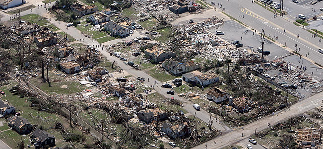 “TUSCALOOSA, Ala. — Southerners found their emergency safety net shredded Friday as they tried to emerge from the second-deadliest day for a twister outbreak in U.S. history.
Emergency buildings are wiped out. Bodies are stored in refrigerated trucks. Authorities are begging for such basics as flashlights. In one neighborhood, the storms even left firefighters to work without a truck.
The death toll from Wednesday’s storms reached 337 across seven states, including at least 246 in Alabama.
The largest death toll ever was on March 18, 1925, when 747 people were killed in storms that raged through Missouri, Illinois and Indiana. The second deadliest day had been in March 1932, when 332 people died, all in Alabama.” Read more.
Killer Twisters Likely Among Largest, Strongest Ever Recorded – Read more.
After Historic Deluge of Tornadoes, is Historic Flooding Next?
 By CAIN BURDEAU – “NEW ORLEANS — A surge of water not seen since the Great Mississippi Flood of 1927 is forecast in coming days to test the enormous levees lining the Mississippi River on its course through the Deep South, adding another element of danger to a region already raked by deadly tornadoes and thunderstorms.
Mississippi’s and Louisiana’s governors issued flood warnings Thursday and declared states of emergency. Authorities along the swollen waterway in both states are warning nearby residents to brace for the possibility of any flooding. River boat casinos in Mississippi are closing and levee managers are readying sand bags and supplies — and the manpower to build the defenses — to fight the rising river along hundreds of levees in both states where the river crosses en route to the Gulf of Mexico.” Read more.
Complete Devastation – ‘This Could Be the Worst Tornado in Alabama’s History’
 “As of 11 p.m. EDT, there have been 135 reports of tornadoes, according to the Storm Prediction Center. Most of these tornadoes have touched down in Alabama, Mississippi and Tennessee, and many have been large, powerful twisters.
After a tornado tore through the Cartersville area of Georgia just after 9 p.m. EDT, another twister was moving through around 10:45 p.m.
A line of severe thunderstorms, some capable of producing tornadoes, was tracking toward Atlanta as of 10:45 p.m.
This is an extremely dangerous situation with serious concern for loss of life and property. All people in the path of these thunderstorms need to get to a safe shelter immediately if a tornado or severe thunderstorm warning is issued…
AccuWeather.com Meteorologist Josh Nagelberg reported that the supercell thunderstorm that produced the Tuscaloosa tornado was still producing a tornado three hours later in northwestern Georgia. The twister passed within a few miles of Rome, Ga., just after 9 p.m. EDT with reports of destruction to homes. ‘This could be the worst tornado in Alabama’s history,’ Nagelberg stated.” Read more.
—
—
Ecuador Raises Alert as Tungurahua Volcano Spews Ash Plume More Than 7km High
 “Ecuador has declared an amber alert after the Tungurahua volcano started spewing ash again.
A plume more than 7km (4.3 miles) high could be seen emerging from the volcano in central Ecuador.
The authorities evacuated residents living near the volcano’s rim and ordered local schools to close.
The Tungurahua has erupted periodically over the past 12 years, but this is its first significant activity this year.” Read more.
More Severe Weather Forecast For Southern US States – Very Large hail and Damaging Winds
 “(CNN) — A rare and dangerous outbreak of severe thunderstorms and possible tornadoes could erupt Tuesday afternoon across parts of the South, from northeast Texas to the Mississippi River, the National Weather Service said Tuesday.
Locations including northeast Texas, far southeast Oklahoma, extreme northwestern Louisiana and the southern half of Arkansas are at high risk for severe thunderstorms late Tuesday afternoon and into Tuesday night, according to the Weather Service’s Storm Prediction Center in Norman, Oklahoma.
‘Dangerous tornado and severe thunderstorm outbreak expected late this afternoon into tonight from northeast Texas … to the Mississippi River,’ forecasters said.
Typically, only a handful of days per year reach high-risk criteria, said CNN meteorologist Dave Hennen.
‘Very large hail and damaging winds’ can also be expected, forecasters said.” Read more.
Britain on Drought Alert as UK as Dry as the Sahara Desert
 By Ruth Doherty – “Britain is on drought alert after experts say some parts of the UK have been as dry as the Sahara Desert at this time of year.
Hosepipe bans are ‘inevitable’, they say, as water shortages are a ‘real and stark danger’ this summer.
The past two months have seen the opposite of the typical spring showers, with virtually no rain at all, making it the driest spring for nearly a century.
And, with no immediate sign of heavy rainfall on the way, experts say the next few weeks will be critical for water companies, farmers and wildlife.
Reservoir levels in parts of the country are already well below average, and some suppliers are resorting to pumping river water to keep them topped up.” Read more.
Experts: Drought Could Continue in Southern U.S. for Several Months, Intensify
 By ANGELA K. BROWN – “FORT WORTH, Texas — The extreme drought that has gripped parts of nine states — most of them in the South — is expected to drag on for several months or intensify, posing a risk for more wildfires, agriculture problems and water restrictions, national weather experts said Monday.
Portions of Texas and a small part of eastern Louisiana are the only parts of the nation that rank in the National Weather Service’s worst drought condition category, said Victor Murphy, the climate service program manager for the southern region, based in Fort Worth. The ‘exceptional’ drought level happens once every 50 to 100 years, he said.
Much of the rest of Texas and Louisiana are in extreme drought conditions — the worst in 20 to 50 years — as are parts of Arizona, New Mexico, Oklahoma, Arkansas and Florida and tiny portions of Colorado and Kansas. Other areas of those states are experiencing severe and moderate drought conditions, along with parts of Mississippi, Alabama, Georgia and South Carolina.” Read more.
 Israel National News
- In two waves of strikes: IDF destroys key Iranian weapons factories and missile launchers
- Residents of northern Israel may leave protected spaces
- Sirens in northern Israel due to launches from Lebanon
- Residents in Nahariya and the area may leave protected spaces, no injuries reported
- Sirens in Nahariya and the area due to launches from Lebanon
- Home Front Command: It is permitted to leave protected spaces, no injuries in latest barrage
- With the start of Shabbat in Israel, Arutz Sheva's North American desk will update the site
- Shabbat Shalom from Israel!
- Vayikra: Maimonides and Korbanot
- Sirens in Samaria and Sharon regions due to launches from Iran
FrontPage Magazine
- First Muslim Judge Blocks Ban on Trans Child Mutilation
- Double Murderer Freed by Newsom’s Parole Board Killed a Woman
- Why Hasn’t House Oversight Called in the Judge Who Was Epstein’s Lawyer?
- Joe Kent and the Company He Keeps
- The Child Rapes of Cesar Chavez
- Inside the Manosphere
- Larijani’s Last Words
- First Muslim Judge Uses $100M Muslim Fraud to Stage DOJ Coup
- Jamie Glazov on Stakelbeck Tonight: Trump – The Last Line of Defense for Western Civilization
- Heartwarming Musical: Making Islam and Sharia Easy to Understand for Everyone of all Ages
Gatestone Institute
- The UAE Will Not Be Bullied by Iran — Nor Derailed From Peace
- Pakistan: Exponentiating Persecution of Religious Minorities
- US Direct Talks with Hamas: Legitimizing and Empowering Terrorists
- Why Iran Was Always a Threat to the US
- Iran Picked a Fight with the Wrong President
- Iran's 'Doomsday Clock' Against Israel No Longer Ticking But Guess Who Is Waiting in the Wings
- Why Applying the 'Venezuela Method' to Iran Would Be a Terrible Mistake
- Hamas Crimes No One Talks About
- Trump's Iran War Ending Xi Jinping's 'China Dream'
- Iran Gets a New Supreme Guide
Middle East – The Jerusalem Post
- Ukraine deploys 228 specialists to five Middle East countries to intercept drones
- Iran's Quds Force chief Qaani lauds anti-US, Israel front, in first message since war started
- Khamenei urges media to avoid Iran's ‘weaknesses,’ accuses Israel of ‘false flag’ attacks
- US deploying thousands of Marines, sailors to Middle East as Iran war rages
- From revolutionaries to royalists? Why some of Iran's former leftists now back Reza Pahlavi
- Iran warns US, Israeli personnel unsafe worldwide after strikes killing regime officials
- Netherlands tightens security for Iranian dissidents after shooting of man critical of Iran
- Gulf states seek to balance diplomacy with deterrence policies as Iran war threatens region
- US intensifies campaign to reopen Strait of Hormuz, deploys A-10s, Apaches - report
- US airlines project confidence as fuel costs surge in wake of US-Israeli war on Iran - analysis
Earthquakes & Volcanic Activity
- World Earthquake Report for March 2026
- World Earthquake Report for Friday, 20 March 2026
- Volcanoes Today, 20 Mar 2026: Fuego volcano, Popocatépetl, Merapi, Semeru, Shiveluch, Ibu, Dukono, Marapi
- Ibu Volcano Volcanic Ash Advisory: ERUPTION LAST REPORTED AT 20/0744Z EST VA DTG: 20/1730Z
- Mayon Volcano Volcanic Ash Advisory: ERUPTION AT 20260320/1617Z VA CLD UNKNOWN REPORTED OBS VA DTG: 20/1620Z
- Fuego Volcano Volcanic Ash Advisory: OCNL TO FRQT VA EMS. to 15000 ft (4600 m)
- Sabancaya Volcano Volcanic Ash Advisory: NO VA ERUPTION
- Aoba Volcano Volcanic Ash Advisory: CONTINUOUS LOW-LEVEL ERUPTION EST VA DTG: 20/1511Z
- Canlaon Volcano Volcanic Ash Advisory: ERUPTION AT 20260320/1302Z FL090 EXTD SW REPORTED OBS VA DTG: 20/1320Z
- Popocatépetl Volcano Volcanic Ash Advisory: NEW VA EMS to 21000 ft (6400 m)
Islamic Terrorist Network In America

Click For Larger Version


Click To Learn What Makes This An Idol


Recent Comments